
Fayl:Daito islands en.png

Bu prevyuning hajmi: 800 × 485 piksel. Boshqa oʻlchamlari: 320 × 194 piksel | 640 × 388 piksel | 1 024 × 621 piksel | 1 458 × 884 piksel.
Asl fayl (1 458 × 884 piksel, fayl hajmi: 324 KB, MIME tipi: image/png)
Qisqa izoh
| Taʼrif |
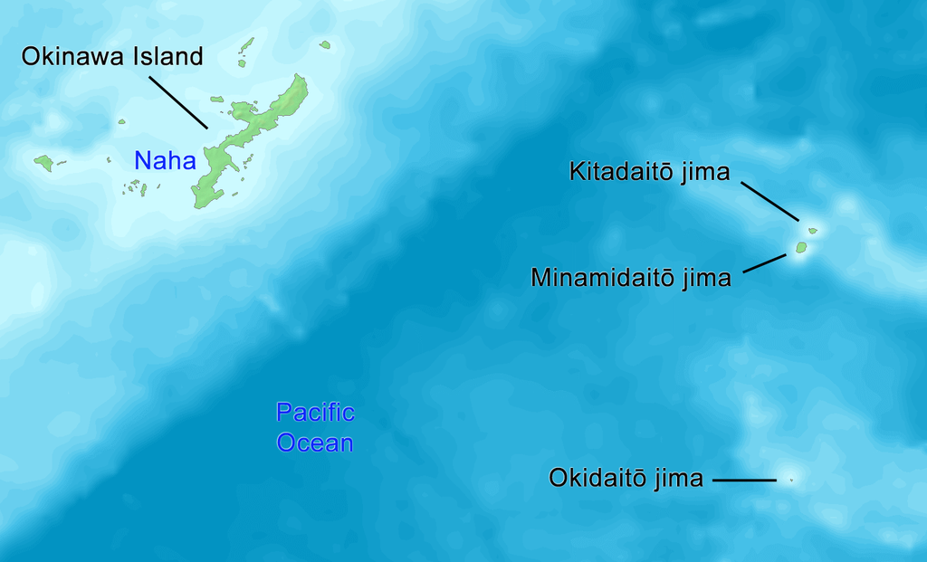
English: Map of Daito Islands (in English).
日本語: 大東諸島の地図(英語)。 |
||||
| Sanasi | |||||
| Manba | http://www.demis.nl/wms/mapclip.htm | ||||
| Muallif | Tdk | ||||
| Ruxsat (Bu faylning takror foydalanilishi) |
|
Litsenziyalash
| I, the copyright holder of this work, release this work into the public domain. This applies worldwide. In some countries this may not be legally possible; if so: I grant anyone the right to use this work for any purpose, without any conditions, unless such conditions are required by law. |
Fayl tarixi
Faylning biror paytdagi holatini koʻrish uchun tegishli sana/vaqtga bosingiz.
| Sana/Vaqt | Miniatura | Oʻlchamlari | Foydalanuvchi | Izoh | |
|---|---|---|---|---|---|
| joriy | 14:58, 14-Oktyabr 2019 | | 1 458 × 884 (324 KB) | Artanisen | {{en|English: High quality map of the Daito Islands. Created with DEMIS World Map Server.}} {{ja|日本語:高品質の地図、大東諸島。}} |
| 03:58, 8-Iyun 2008 |  | 615 × 461 (87 KB) | Tdk~commonswiki | {{Information |Description={{en|1=Map of Daito Islands.(in English)}} {{ja|1=大東諸島の地図。(英語)}} |Source=http://www.demis.nl/wms/mapclip.htm |Author=Tdk |Date=2008/6/8 |Permission={{demis-pd}} |other_versions= }} {{ImageUpload|full}} |
Fayllarga ishoratlar
Bu faylga quyidagi sahifa bogʻlangan:
Faylning global foydalanilishi
Ushbu fayl quyidagi vikilarda ishlatilyapti:
- az.wikipedia.org loyihasida foydalanilishi
- cs.wikipedia.org loyihasida foydalanilishi
- de.wikipedia.org loyihasida foydalanilishi
- en.wikipedia.org loyihasida foydalanilishi
- es.wikipedia.org loyihasida foydalanilishi
- eu.wikipedia.org loyihasida foydalanilishi
- fi.wikipedia.org loyihasida foydalanilishi
- fr.wikipedia.org loyihasida foydalanilishi
- it.wikipedia.org loyihasida foydalanilishi
- ko.wikipedia.org loyihasida foydalanilishi
- lt.wikipedia.org loyihasida foydalanilishi
- no.wikipedia.org loyihasida foydalanilishi
- pl.wikipedia.org loyihasida foydalanilishi
- pt.wikipedia.org loyihasida foydalanilishi
- ru.wikipedia.org loyihasida foydalanilishi
- sv.wikipedia.org loyihasida foydalanilishi
- tr.wikipedia.org loyihasida foydalanilishi
- uk.wikipedia.org loyihasida foydalanilishi
- vi.wikipedia.org loyihasida foydalanilishi
- www.wikidata.org loyihasida foydalanilishi
- zh-classical.wikipedia.org loyihasida foydalanilishi
- zh-yue.wikipedia.org loyihasida foydalanilishi