Fayl:Portolan chart of Guillem Soler (c.1380, Paris).jpg

Sahifa kontenti boshqa tillarda dastaklanmaydi.
Vikipediya, ochiq ensiklopediya

Asl fayl(16 908 × 10 882 piksel, fayl hajmi: 24,64 MB, MIME tipi: image/jpeg)

Ushbu fayl Vikiomborga yuklangan boʻlib, boshqa loyihalarda ham qoʻllanilishi mumkin. Uning tavsif sahifasidan olingan maʼlumot quyida keltirilgan.

Qisqa izoh

Warning The original file is very high-resolution. It might not load properly or could cause your browser to freeze when opened at full size.
Guillem Soler: Català: Guillmus Soleri civis maioricaru me fecit   (Wikidata search (Cirrus search) Wikidata query (SPARQL)  Create new Wikidata item based on this file)
Artist
Guillem Soler  (14 century
date QS:P,+1350–00–00T00:00:00Z/7
 wikidata:Q3651379
 
Guillem Soler
Alternative names
Guillelmus Soleri; Guillermo Soler; Guglielmo Soleri; Guillermi Solerii
Description Catalan cartographer
Date of birth/death 14 century
date QS:P,+1350-00-00T00:00:00Z/7
 Edit this at Wikidata
15 century
date QS:P,+1450-00-00T00:00:00Z/7
 Edit this at Wikidata
Location of birth/death Mallorca Mallorca
Work location
Hokimiyat nazorati
artist QS:P170,Q3651379
Title
Català: Guillmus Soleri civis maioricaru me fecit
Taʼrif
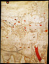
English: Portolan chart signed by Majorcan cartographer Guillem Soler (Guillelmus Soleri, Guglielmo Soleri) but undated (est. c.1380, but could be anywhere between 1368 and 1385), held by the Bibliothèque nationale de France in Paris, France.
Français : Carte marine de l'océan Atlantique Est, de la mer Méditerranée, de la mer Noire et de la mer Rouge / Guillmus Soleri civjs maioric[arum] me fecit
Sanasi 1380
date QS:P571,+1380-00-00T00:00:00Z/9
Dimensions balandligi/bo'yi: 65 cm; width: 102 cm
dimensions QS:P2048,65U174728
dimensions QS:P2049,102U174728
institution QS:P195,Q193563
Current location
Paris
Accession number
CPL GE B-1131 (RES)
Source/Photographer
Bibliothèque nationale de France
Other versions

Litsenziyalash

Previous public domain rationale, no longer applicable
Public domain

العربية  Deutsch  English  español  français  galego  italiano  日本語  македонски  Nederlands  português  русский  sicilianu  slovenščina  українська  +/−

This is a faithful photographic reproduction of a two-dimensional, public domain work of art. The work of art itself is in the public domain for the following reason:
Public domain

This work is in the public domain in its country of origin and other countries and areas where the copyright term is the author's life plus 100 years or fewer.


You must also include a United States public domain tag to indicate why this work is in the public domain in the United States.
The official position taken by the Wikimedia Foundation is that "faithful reproductions of two-dimensional public domain works of art are public domain".
This photographic reproduction is therefore also considered to be in the public domain in the United States. In other jurisdictions, re-use of this content may be restricted; see Reuse of PD-Art photographs for details.

Fayl tarixi

Faylning biror paytdagi holatini koʻrish uchun tegishli sana/vaqtga bosingiz.

Sana/VaqtMiniaturaOʻlchamlariFoydalanuvchiIzoh
joriy01:24, 7-Fevral 202101:24, 7-Fevral 2021 dagi versiya uchun tasvir16 908 × 10 882 (24,64 MB)One2hq
13:17, 17-Iyul 201113:17, 17-Iyul 2011 dagi versiya uchun tasvir5 587 × 3 552 (8,15 MB)WalrasiadLarger resolution file
18:43, 19-Iyun 201118:43, 19-Iyun 2011 dagi versiya uchun tasvir576 × 357 (70 KB)Walrasiad{{Information |Description ={{en|1=Portolan chart signed by Majorcan cartographer [w:Guillem Soler|Guillem Soler]] (Guillelmus Soleri, Guglielmo Soleri) but undated (est. c.1380, but could be anywhere between 1368 and 1385), held by the Bibliothè

Bu faylga bogʻlangan sahifalar yoʻq.

Faylning global foydalanilishi

Ushbu fayl quyidagi vikilarda ishlatilyapti: