
Fayl:Tangent galvanometer Philip-Harris top1.jpg
Bu prevyuning hajmi: 600 × 600 piksel. Boshqa oʻlchamlari: 240 × 240 piksel | 480 × 480 piksel | 768 × 768 piksel | 1 024 × 1 024 piksel.
Asl fayl (1 024 × 1 024 piksel, fayl hajmi: 105 KB, MIME tipi: image/jpeg)
Qisqa izoh
| Taʼrif |
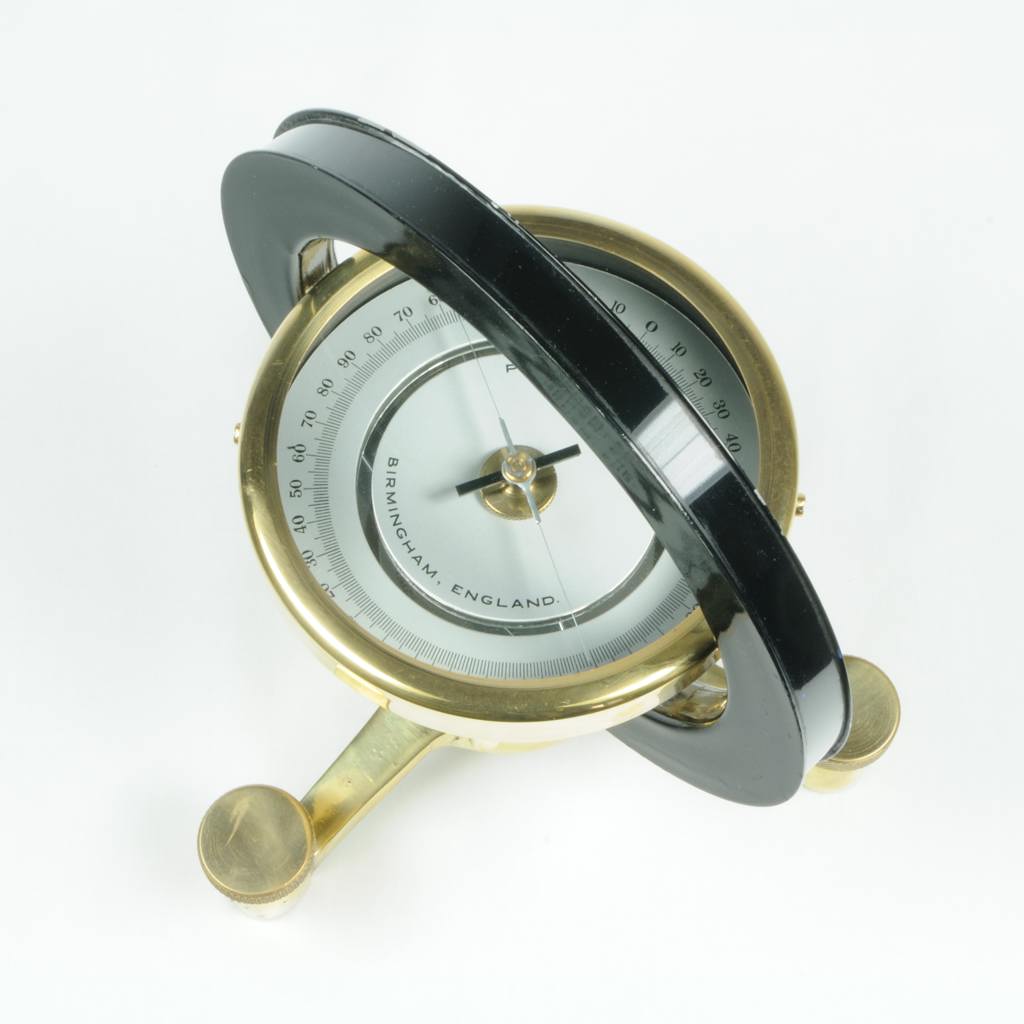
English: en:Tangent galvanometer made by en:Philip Harris Ltd., Birmingham, England, ca. 1950. From the Sammlung historischer Messtechnik (Collection of historical measurement apparatus), A. Kusdas. In the middle of the galvanometer is a compass that is aligned to be horizontal using the brass leveling screws. The black ring has a diameter of 17 cm; it houses a circular coil of wire. In use, the galvanometer is rotated on a table so that this ring is parallel to the direction of the earth's local magnetic field, and the compass needle will be parallel to the ring. As can be seen, the apparatus was not aligned when the photograph was taken. When a source of electrical current is hooked up to the coil, the resulting magnetic field causes the compass needle to rotate away from its initial alignment parallel to the coil. The angle of rotation is used to calculate the current through the coil. |
| Sanasi | |
| Manba | http://www.historische-messgeraete.de/images/gb_philip-harris_tangent-galvanometer1_top1.jpg |
| Muallif | Alexander Kusdas |
| Ruxsat (Bu faylning takror foydalanilishi) |
Lizenzbestimmungen (in German). Sammlung historischer Messtechnik. Retrieved on 2012-12-20. Licensing for re-use of text and photographs from the website http://www.historische-messgeraete.de is offered under the German version of the CC-BY-SA 3.0. |
| Other versions | There are links to about a dozen photographs of the same apparatus from different perspectives at Tangential-Galvanometer, Philip Harris, ca. 1950 (in German). Sammlung historischer Messtechnik. Retrieved on 2012-12-20. |
Litsenziyalash
Bu fayl Creative Commons asosida litsenziyalangan Attribution- Share Alike 3.0 Unported litsenziyasi.
- Siz erkinsiz:
- ulashishga – ishlanmani nusxalash, tarqatish va uzatish
- remiks qilishga – ishni moslashtirishga
- Quyidagi shartlar asosida:
- atribut – Siz tegishli litsenziyaga havolani taqdim etishingiz va oʻzgartirishlar kiritilganligini koʻrsatishingiz kerak. Siz buni har qanday oqilona yoʻl bilan qilishingiz mumkin, lekin litsenziar Sizni yoki Sizning foydalanishingizni ma'qullashini taklif qiladigan tarzda emas.
- bir xil ulashish – Agar Siz materialni remiks qilsangiz, oʻzgartirsangiz yoki unga asoslansangiz, oʻz hissalaringizni asl nusxadagi kabi bir xil yoki mos litsenziya ostida tarqatishingiz kerak.
| Annotations | This image is annotated: View the annotations at Commons |
Fayl tarixi
Faylning biror paytdagi holatini koʻrish uchun tegishli sana/vaqtga bosingiz.
| Sana/Vaqt | Miniatura | Oʻlchamlari | Foydalanuvchi | Izoh | |
|---|---|---|---|---|---|
| joriy | 05:07, 20-Dekabr 2012 | | 1 024 × 1 024 (105 KB) | Easchiff | User created page with UploadWizard |
Fayllarga ishoratlar
Bu faylga quyidagi sahifa bogʻlangan:
Faylning global foydalanilishi
Ushbu fayl quyidagi vikilarda ishlatilyapti:
- de.wikipedia.org loyihasida foydalanilishi
- en.wikipedia.org loyihasida foydalanilishi