Andoza:Vulqon bilgiqutisi
Qiyofa
Ushbu Vulqon bilgiqutisi vulqon otilishi haqidagi sahifalarda va vulqon haqidagi maqolalarning otilishi haqidagi boʻlimlarida foydalanish uchun moʻljallangan, lekin vulqonlarning oʻzlari sahifalarida asosiy shablon sifatida “‘emas” ({{Togʻ bilgiqutisi}}). Shablonning to'liq kengaytirilgan shakli quyidagicha:
{{Vulqon bilgiqutisi
 | name        =
 | image       =
 | image_size  =
 | caption     =
 | date        =
 | start_date  =
 | start_time  =
 | end_date    =
 | end_time    =
 | volcano     =
 | type        =
 | location    =
 | coordinates =
 | VEI         =
 | map         =
 | map_size    =
 | map_caption =
 | impact      =
}}
| Nomi | Kirish |
|---|---|
| name | Nomi. Nisbatan zamonaviy otilishlarni nomlash uchun konventsiyalar "[Yil] otilishi [vulqon]" dan foydalanishdir. Agar vaqt to'liq bo'lmasa (juda eski otilishlar uchun odatiy), yil o'rniga iloji boricha aniq vaqt oralig'idan foydalaning. Ko'pgina otilishlarning ilmiy hamjamiyat tomonidan berilgan nomlari bor, agar mavjud bo'lsa, undan foydalaning! |
| image | Fotosurat ixtiro qilinishidan oldingi portlashlar uchun rasm yoki boshqa tasvirdan foydalanish mumkin. Fayl nomidan oldin “Fayl:” yozing, lekin [ ] qavslardan foydalanmang. |
| image_size | Fotosurat hajmi; Buni bo'sh qoldirish uni sukut bo'yicha 250 pikselga olib keladi. |
| caption | Surat uchun sarlavha. |
| date | Date of eruption; should be used for one day eruptions or when the start and end dates of an eruption are unknown. |
| start_date | Start date of eruption; should be as specific as allowable. |
| start_time | Start time of eruption; should be as specific as allowable. |
| end_date | End date of eruption; should be as specific as allowable. |
| end_time | End time of eruption; should be as specific as allowable. |
| volcano | Name of the volcano where the eruption occurred. |
| type | Type of eruption, see Types of volcanic eruptions for the different types. |
| location | Location of the volcano, e.g. "Boulder Springs, Colorado" |
| coordinates | Coordinates of the volcano. Use Template:Coord. |
| VEI | Volcanic Explosivity Index, a measure of an eruption's strength similar to the Richter scale; the type of eruption can be inferred off its VEI, and this field also automatically adds the volcano to the respective "VEI-level volcanoes" category. |
| map | Map of the eruption, if there is one. You can use a {{Location map}} template in place of a "hard" image map (use width = 250, with caption = ) |
| map_size | Same as image_size, above. |
| map_caption | Caption for the map. |
| impact | What was the impact of the eruption? How many lives were lost? How much property damage? What was the impact of the eruption on the local and global landscape? Basically, why is the eruption notable? |
Here is an example usage:
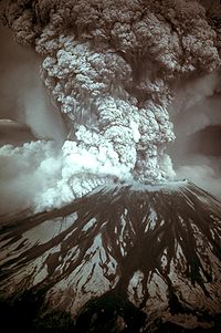
| 1980 eruption of Mount St. Helens | |
|---|---|
 Photograph of the eruption column, May 18, 1980 | |
| Vulqon | Mount St. Helens |
| Boshlangan sana | March 27, 1980 |
| Boshlangan vaqt | 12:36 p.m. PDT |
| Turi | Phreatic, Plinian, Peléan |
| Joylashuvi |
Skamania County, Washington 46°12′1″N 122°11′12″W / 46.20028°N 122.18667°W |
| VEI | 5 |
| Taʼsiri | 57 deaths, $1.1 billion in property damage; caused a partial collapse of the volcano's flank, deposited ash in 11 states |
 Map of eruption deposits | |
created with this source:
{{Infobox eruption
 | name = 1980 eruption of Mount St. Helens
 | image = MSH80 eruption mount st helens 05-18-80-dramatic-edit.jpg
 | image_size = 200px
 | caption = Photograph of the [[eruption column]], May 18, 1980
 | start_date = March 27, 1980
 | start_time = 12:36 p.m. PDT
 | volcano = [[Mount St. Helens]]
 | type = [[Phreatic eruption|Phreatic]], [[Plinian eruption|Plinian]], [[Peléan eruption|Peléan]]
 | location = [[Skamania County, Washington|Skamania County]], [[Washington (state)|Washington]]
 | coordinates = {{coord|46|12|1|N|122|11|12|W|display=inline}}
 | VEI = 5
 | map = St helens map showing 1980 eruption deposits.png
 | map_size =
 | map_caption = Map of eruption deposits
 | impact = 57 deaths, $1.1 billion in property damage; caused a partial collapse of the volcano's flank, deposited ash in 11 states
}}
This template can also be used inside an article, in a section dedicated to an important volcanic eruption. In these cases, the volcano, location, coordinates, and map should be left out, as they are redundant to the main article infobox (presumably Template:Infobox mountain). For instance:
Source:
{{Infobox eruption
 | name = 1914 eruption of Sakurajima
 | image = Kagoshima 1914.jpg
 | image_size =
 | caption = The city of [[Kagoshima]] was covered by deep ash during the 1914 eruption of the Sakurajima, which is visible across the bay.
 | start_date = January 1914
 | start_time =
 | volcano =
 | type = [[Peléan eruption|Peléan]]
 | location =
 | coordinates =
 | VEI = 4
 | map =
 | map_size =
 | map_caption =
 | impact = Pre-eruption earthquakes killed at least 35 people; caused an evacuation and significant changes to the local topology.
}}
| Yuqoridagi hujjat Andoza:Vulqon bilgiqutisi/doc sahifasidan olingan. Tajriba oʻtkazish uchun qumloq va test sahifasidan foydalaning. Iltimos, turkumlarni hujjat sahifasiga va intervikilarni vikimaʼlumotlarga joylashtiring. Ushbu andoza ostsahifalari. |
