
Fayl:Okushiri Island Aerial photograph.2017.jpg

Bu prevyuning hajmi: 423 × 599 piksel. Boshqa oʻlchamlari: 169 × 240 piksel | 339 × 480 piksel | 542 × 768 piksel | 723 × 1 024 piksel | 1 446 × 2 048 piksel | 10 000 × 14 166 piksel.
Asl fayl (10 000 × 14 166 piksel, fayl hajmi: 25,11 MB, MIME tipi: image/jpeg)
Qisqa izoh
| Warning | The original file is very high-resolution. It might not load properly or could cause your browser to freeze when opened at full size. |
|---|
| Taʼrif |
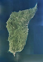
日本語: 奥尻島(北海道奥尻郡奥尻町)の空中写真。CHO20173X-C1-3から同7とCHO20173X-C2-3から同13とCHO20173X-C3-2から同14とCHO20173X-C4-2から同14とCHO20173X-C5-2から同12の合計53枚を合成作成。
English: Okushiri Island Aerial photograph.2017 |
| Sanasi | |
| Manba | 国土情報ウェブマッピングシステム |
| Muallif | 国土地理院 |
Litsenziyalash

|
The copyright holder of this file, the Ministry of Land, Infrastructure, Transport and Tourism of Japan, allows anyone to use it for any purpose, provided that the copyright holder is properly attributed. Redistribution, derivative work, commercial use, and all other use is permitted. |
Attributsiya:
Copyright © National Land Image Information (Color Aerial Photographs), Ministry of Land, Infrastructure, Transport and Tourism
|
 |
This image is copyrighted by the Ministry of Land, Infrastructure, Transport and Tourism of Japan. For terms of use, see the stipulation to use of National Land Information (in Japanese) and message from MLIT (in Japanese and English). When you display this image on an article, include the following phrase in the description: "Made based on National Land Image Information (Color Aerial Photographs), Ministry of Land, Infrastructure, Transport and Tourism".
|
Fayl tarixi
Faylning biror paytdagi holatini koʻrish uchun tegishli sana/vaqtga bosingiz.
| Sana/Vaqt | Miniatura | Oʻlchamlari | Foydalanuvchi | Izoh | |
|---|---|---|---|---|---|
| joriy | 02:38, 26-Dekabr 2020 | | 10 000 × 14 166 (25,11 MB) | さかおり | Uploaded a work by 国土地理院 from 国土情報ウェブマッピングシステム with UploadWizard |
Fayllarga ishoratlar
Bu faylga quyidagi sahifa bogʻlangan:
Faylning global foydalanilishi
Ushbu fayl quyidagi vikilarda ishlatilyapti:
- de.wikipedia.org loyihasida foydalanilishi
- en.wikipedia.org loyihasida foydalanilishi
- fr.wikipedia.org loyihasida foydalanilishi
- ja.wikipedia.org loyihasida foydalanilishi
- sv.wikipedia.org loyihasida foydalanilishi