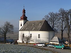
Jedlí
Qiyofa
Jedlí | |
|---|---|
 Church of Saint John the Baptist | |
| Koordinatalari: 49°55′52″N 16°47′41″E / 49.93111°N 16.79472°E | |
| Country |
|
| Region | Olomouc |
| District | Šumperk |
| First mentioned | 1351 |
| Hudud | |
| • Umumiy | 9,93 km2 (4 sq mi) |
| Balandligi | 485 m (1 600 ft) |
| Aholisi (2022-01-01)[1] | |
| • Umumiy | 674 |
| • Zichligi | 68/km2 (180/sq mi) |
| Vaqt mintaqasi | UTC+1 (CET) |
| • Yoz (DST) | UTC+2 (CEST) |
| Postal codes |
789 92 |
| Veb-sayt | jedli.zabrezsko.cz |
Jedlí Chexiya respublikasida joylashgan aholi punkti. Uning 674 ga yaqin aholisi bor.
Manbalar
[tahrir | manbasini tahrirlash]- ↑ „Population of Municipalities – 1 January 2022“. Czech Statistical Office (2022-yil 29-aprel).


