Modul:Location map/data/Germany Neckar/doc
Bu sahifa Modul:Location map/data/Germany Neckar uchun hujjat sahifasidir
| name | Neckar | ||
|---|---|---|---|
| x | (100*( ($2 - (9.67 + 8.0)/2)*((1 - 0.86)*($1 - 49.71)/(48.0 - 49.71) + 0.86) + (9.67 + 8.0)/2 - 8.0)/(9.67 - 8.0)) | ||
| y | (100*($1 - 49.71)/(48.0 - 49.71)) | ||
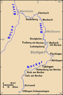
| image | Neckar_watershed_closer.gif
| ||

| |||
Modul:Location map/data/Germany Neckar joylashuv xaritasi taʼrifi boʻlib, an equirectangular projection Neckardagi markerlar va yorliqlarni joylashtirish uchun foydalaniladi. :Modul:Location map/data/Germany Neckar/doc|1|3}}|ism}}]]}}}. Markerlar standart xaritada yoki shunga o'xshash xarita tasvirida kenglik va uzunlik koordinatalari bo'yicha joylashtiriladi.
Qoʻllanilishi
Ushbu ta'riflar parametr bilan chaqirilganda quyidagi andozalar tomonidan qo'llaniladi „Germany Neckar“:
{{Location map | Germany Neckar | …}}{{Location map many | Germany Neckar | …}}{{Location map+ | Germany Neckar | …}}{{Location map~ | Germany Neckar | …}}
Xarita tavsifi
name = Neckar- Standart xarita sarlavhasida foydalanilgan ism
image = Neckar_watershed_closer.gif- Standart xarita tasviri, “Rasm:” yoki “Fayl:”siz
x = (100*( ($2 - (9.67 + 8.0)/2)*((1 - 0.86)*($1 - 49.71)/(48.0 - 49.71) + 0.86) + (9.67 + 8.0)/2 - 8.0)/(9.67 - 8.0))- An expression to calculate a location on the map via its longitude; evaluates as 0 along the left edge and 100 along the right edge
y = (100*($1 - 49.71)/(48.0 - 49.71))- An expression to calculate a location on the map via its latitude; evaluates as 0 along the top edge and 100 along the bottom edge
Xaritalar joylashuvi andozalariga misollar
Mannheim
The example on the left shows the correct placement of Mannheim when Germany Neckar is used with {{Location map}}.
Note that the marker for "Mannheim" is west of the mark, due to narrow longitudes far north (on non-equirectangular map). Longitude lines converge to the center, so center towns would be positioned more accurately. The "polar" skew factor should be used (as in Template:Location map) to scale longitude smaller near polar latitudes (relative to map height), and position longitudes from map center, rather than left-side base longitude (see example below).
{{Location map | Germany Neckar
 | width = 250 | float = right
 | caption = Example using ''Location map''
 | label = Mannheim | label_size = 90
 | background = #CCCC11 | position = bottom
 | lat_deg = 49.4890
 | lon_deg = 8.4691
 }}
Rottweil
The example shows the correct placement of Rottweil when Germany Neckar is used with {{Location map}}.
{{Location map | Germany Neckar
 | width = 250 | float = right
 | caption = Example using ''Location map''
 | label = Rottweil | label_size = 90
 | background = #FFCC66 | position = top
 | lat_deg = 48 | lat_min = 10 |lat_sec = 05
 | lon_deg = 08 | lon_min = 37 |lon_sec = 29
 }}
Multiple markers on one map
The example on the left shows the correct placement of locations when Germany Neckar is used with {{Location map}}.
{{Location map many | Germany Neckar
 | width = 250 | float = right
 | caption = Example using ''Location map many''
 | label = Mannheim | label_size = 100
   | bg = #CCCC11 | pos = bottom
   | lat_deg = 49.4890
   | lon_deg = 8.469
 | label2 = Rottweil | label2_size = 100
   | bg2 = #66BBDD | pos2 = top
   | lat2_deg = 48 | lat2_min = 10
   | lon2_deg = 08 | lon2_min = 37.5
 | label3 = Heilbronn | label3_size = 90
   | bg3 = #FFFF99 | pos3 = top
   | lat3_deg = 49 | lat3_min = 9
   | lon3_deg = 09 | lon3_min = 13
 }}
Yana qarang
- Module:Location map/data/Germany
- Module:Location map/data/Germany Rhine
- Module:Location map/data/Germany Weser
Xaritalar joylashuvi andozalari
- Template:Location map, to display one mark and label using latitude and longitude
- Template:Location map many, to display up to nine marks and labels
- Template:Location map+, to display an unlimited number of marks and labels

