Crows Nest (Indiana)
Qiyofa
Bu maqolaga boshqa birorta sahifadan
ishorat yoʻq. (avgust 2024) |
Crows Nest | |
|---|---|
| Shahar | |
 | |
| 39°51′8″N 86°10′22″W / 39.85222°N 86.17278°W | |
| Mamlakat | AQSh |
| Shtat | Indiana |
| Okrug | Marion |
| Dengiz sathidan balandligi | 236 m |
| Aholisi (2010) |
73 |
| Zichligi | auto kishi/km2 |
| Vaqt mintaqasi | UTC-5, yozda UTC-4 |
| FIPS kodi | 18-16156[1] |
|
| |
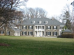
Crows Nest AQShning Indiana shtatida joylashgan shahardir. Marion okrugi tarkibiga kiradi.
Aholisi
[tahrir | manbasini tahrirlash]73 nafar aholi istiqomat qiladi (2010). Aholi zichligi – har kvadrat kilometrga auto nafar kishi.
Manbalar
[tahrir | manbasini tahrirlash]- ↑ „American FactFinder“. United States Census Bureau. Qaraldi: 2008-yil 31-yanvar.
Havolalar
[tahrir | manbasini tahrirlash]Town of Crows Nest Historic District
Lua xatosi in Modul:Location_map at line 522: Unable to find the specified location map definition: "Module:Location map/data/Indiana" does not exist.Joylashuv Roughly bounded by Kessler Blvd., White R., and Questover Circle, IndianapolisHudud 65 akr (26 ga)Meʼmorchilik uslubi Colonial Revival, Tudor Revival, et al.NRHP maʼlumotnomasi No. 00000305[1]NRHPga qoʻshilgan 13-aprel 2000-yil


